If you still want to continue on our English site, please click herePlease note that we do not deliver to your country in case you wish to proceed here
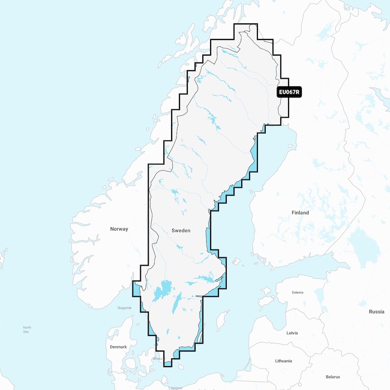
Plot your paradise - with the best and most up - to - date Garmin Navionics + charts. The new charts have a very detailed mapping of coastal areas, lakes, rivers and more.
Productinformation
The charts have shaded deep contours to help with navigation in shallow water and to find the best fishing spots. With a new advanced Auto Guidance + technology for the best choice of guidance on the water and this with the help of Garmin and Navionc's route solution are now integrated. Access to daily updates via the ActiveCaptain® app for the latest chart data.
INTEGRATED CONTENT Integrated Garmin and Navionics content for oceans and lakes - with an updated Navionics-style color palette that provides exceptional coverage, clarity and detail.
DAILY UPDATES A one-year subscription with daily chart updates is downloaded via the ActiveCaptain app.
AUTO GUIDANCE + By combining the best of Garmin's and Navionic's automatic route functions, the built-in Auto Guidance + technology gives you the easiest way from start to finish, such as going through canals, inlets and more.
SHADOWING ON CONTOURS Shading with depth intervals, choose between 10 color shades. UP TO 0.5 m
CONTOURS Improved for fishing and navigation that gives up to 0.5m contours a more detailed view of the bottom structure.
SHADOWING ON NAVIGATION MAP To facilitate navigation, you can set the deep contours to suit you best.
ACTIVECAPTAIN COMMUNITY ActiveCaptain Community where you can give recommendations and take advice from other boat owners, everything from guest harbors to marinas.
Specifications
Questions & Answers
Related Reports & Guides
There are currently no blogs connected to this article.
Product Safety Information (GPSR)
Importer
Registered contact information for the responsible company within the EU.
Plot your paradise - with the best and most up - to - date Garmin Navionics + charts. The new charts have a very detailed mapping of coastal areas, lakes, rivers and more.
Productinformation
The charts have shaded deep contours to help with navigation in shallow water and to find the best fishing spots. With a new advanced Auto Guidance + technology for the best choice of guidance on the water and this with the help of Garmin and Navionc's route solution are now integrated. Access to daily updates via the ActiveCaptain® app for the latest chart data.
INTEGRATED CONTENT Integrated Garmin and Navionics content for oceans and lakes - with an updated Navionics-style color palette that provides exceptional coverage, clarity and detail.
DAILY UPDATES A one-year subscription with daily chart updates is downloaded via the ActiveCaptain app.
AUTO GUIDANCE + By combining the best of Garmin's and Navionic's automatic route functions, the built-in Auto Guidance + technology gives you the easiest way from start to finish, such as going through canals, inlets and more.
SHADOWING ON CONTOURS Shading with depth intervals, choose between 10 color shades. UP TO 0.5 m
CONTOURS Improved for fishing and navigation that gives up to 0.5m contours a more detailed view of the bottom structure.
SHADOWING ON NAVIGATION MAP To facilitate navigation, you can set the deep contours to suit you best.
ACTIVECAPTAIN COMMUNITY ActiveCaptain Community where you can give recommendations and take advice from other boat owners, everything from guest harbors to marinas.
COOKIES Söder Sportfiske AB uses cookies and similar storage technologies to provide you with tailored content, relevant marketing and a better experience with our e-commerce and website.You acknowledge that you have read our Cookie Policy and agree to our use of cookies by clicking "Accept". You can always check which cookies are stored in your browser under "Settings". You can read more about this in our Privacy Policy and Cookie Policy.
NecessaryNecessary cookies enable basic functions so that the website works safely and correctly. Therefore, they cannot be turned off.
Social MediaCookies in connection with social media.
MarketingMarketing cookies are used for advertising where, with the help of our partners, we can communicate the type of offers we deem most relevant to you and your preferences.
Analysis and statisticsThese cookies provide us with information about the user experience of our website and allow us to work on improving user-friendliness, customer service and other similar features.
Necessary
Social Media
Marketing
Analysis and statistics
Save & Close
COOKIES Söder Sportfiske AB uses cookies and similar storage technologies to provide you with tailored content, relevant marketing and a better experience with our e-commerce and website. Cookies may be used for personalized and non-personalized advertising. You acknowledge that you have read our Cookie Policy and agree to our use of cookies by clicking "Accept". You can always check which cookies are stored in your browser under "Settings". You can read more about this in our Privacy Policy and Cookie Policy.
 Åland (excl. vat)
 Austria
 Belgium
 Bulgaria
 Croatia
 Czech Republic
 Denmark
 Estonia
 Finland
 France
 Germany
 Greece
 Hungary
 Ireland
 Italy
Italy Latvia
 Lithuania
 Netherlands
 Norway
 Poland
 Portugal
 Romania
 Slovakia
 Slovenia
 Spain
Spain Sverige
 Switzerland (excl. vat)