Select your shipping country
 Åland (excl. vat)
 Austria
 Belgium
 Bulgaria
 Croatia
 Czech Republic
 Denmark
 Estonia
 Finland
 France
 Germany
 Greece
 Hungary
 Ireland
 Italy
Italy Latvia
 Lithuania
 Netherlands
 Norway
 Poland
 Portugal
 Romania
 Slovakia
 Slovenia
 Spain
Spain Sverige
 Switzerland (excl. vat)
If you still want to continue on our English site, please click here
Please note that we do not deliver to your country in case you wish to proceed here


Sold out
Pictures
Video
9
In stock
In store
In store
For Immediate Delivery
Summary
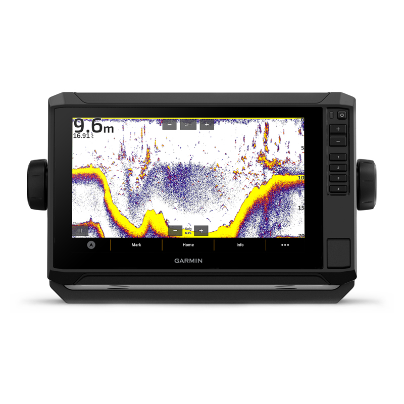
Garmin Echomap UHD2 Touch 92sv, WW w/GT56 XDCR is a touchscreen sonar with enhanced detail, Garmin sonar, ClearVü™ and SideVü™ sonar. Know the water better than a local!
Productinformation
When it comes to catching more fish, they say, “Talk to a local.” With the ECHOMAP UHD2 chartplotter, which offers our best-in-class sonar and mapping and premium touchscreen display with keyed-assist, you’ll know the water even better than they do.
Sonar Support
With crisp, clear traditional sonar and brilliant ClearVü and SideVü scanning sonars, the fish will have nowhere to hide. Your ECHOMAP UHD2 also supports LiveScope™ live-scanning sonar.
Vivid Color Palettes
High-contrast vivid scanning sonar color palettes make it easier than ever to distinguish targets and structure.
Bundle your transducer
Your ECHOMAP UHD2 device supports a variety of Garmin transducers. The 6” and 7” chartplotters come bundled with a GT54 transducer — while the 9” chartplotter comes with a GT56 transducer.
Preloaded Charts
You’ve never seen Garmin cartography like this before. Select chartplotters come with built-in Garmin Navionics+ cartography which includes a 1-year subscription for daily updates, depth range shading and more.
Wireles Networking
If you have another compatible ECHOMAP UHD2 chartplotter on your boat, you can wirelessly share information — such as sonar1, waypoints and routes — with them.
Activecaptain® App
Built-in Wi-Fi® connectivity pairs with the free all-in-one mobile app on your compatible smartphone for access to the OneChart™ feature, smart notifications, software updates, Garmin Quickdraw™ Community data and more2.
Auto Guidance+™ Technology
Chartplotters with built-in Garmin Navionics+ charts include downloadable Auto Guidance+ technology3 with the ActiveCaptain app.
Troll with Force®
Your ECHOMAP UHD2 wirelessly connects to your Force trolling motor to create and follow routes, navigate to waypoints, control speed, check battery life and more.
Multi-Band GPS
Get improved position accuracy, particularly in areas where signals are reflected or weak, with multi-band GPS.
Included
GT56UHD-TM Sensor
Power cable
Swivel mount with quick-release holder
Protective case
Material
Documentation
General
Physical dimensions: 10.4″ x 6.5″ x 3.2″ (26.4 x 16.6 x 8 cm)
Touch screen: yes
Touch buttons: touch screen and buttons
Screen size, w x h: 7.8″ x 4.5″, 9″ (19.8 x 11.5 cm, 22.9 cm)
Screen resolution, w x h: 1024 x 600 pixels
Screen type: WVGA, TN
Weight: 2.9 lbs (1.3 kg)
Water rating: IPX7
Mounting options: mounting bracket or flush mount
Maps and memory
Accepts data cards: 1 microsd™ card, 32 gb maximum size
Waypoints: 5,000
Waypoints: 50,000
Tracks: 50 saved tracks
Routes: 100
Sensors
Has built-in receiver: Yes
Receiver: 10 hz
Compatible with nmea 2000®: Yes
GPS: Yes
Glonass: Yes
Galileo: Yes
Beidou: Yes
Supports WAAS: Yes
Support for multi-band, multi-constellation GPS: Yes
Built-in maps
Built-in auto guidance+: Yes (can be downloaded via the activecaptain app)
Garmin navionics+: Yes (see additional)
Garmin navionics+™: Yes (see additional)
Garmin navionics+: Yes (see additional)
Tide tables: Yes (see additional)
Optional map support
Garmin navionics+™: Yes
Garmin navionics vision+™: Yes
Topo: Yes
Standard mapping: Yes
Garmin quickdraw contours: Yes
Recommended plotters
Supports ais (tracks the position of object vessels): Yes
Supports dsc (displays position data from vhf radio with dsc function): Yes
Support for fusion-link™ compatible radio: Yes
Compatible with activecaptain: Yes
Sailing functions: Yes
Recommended sonar and specifications
Sonar display: Yes
Output power: 500 w
Traditional sonar (dual frequency/beam): built-in (single channel chirp sonar, 50/77/83/200 khz, low, medium or high chirp sonar)
Clearvü: Built-in 260/455/800/1000/1200 khz
Sidevü: Built-in 260/455/800/1000/1200 khz
Panoptix™ Sonar: Yes
Livescope: Yes
Connections
NMEA 2000® ports: Yes
Garmin marine network™ ports: 1
12-pin sensor ports: 1
Bluetooth® calling: Yes
Ant+™ (connectivity): Yes
Garmin wi-fi® network (local connection): Yes
Electrical specification
Voltage supply: 9 to 18 v DC
Typical power consumption at 12 v DC: 1.72 a
Maximum power consumption at 12 v DC: 3.5 a
Maximum power consumption at 10 v DC: 20.7 w
- The bright 9” touchscreen display with keyed-assist is user-friendly and easy to read
- Good things come in threes. Three sonar types, that is: Garmin traditional, ClearVü™ and SideVü™ sonars.
- Improved detail? Check. Distinguished targets? Yep. That’s the beauty of high-contrast vivid color palettes.
- If you’re running another ECHOMAP UHD2 chartplotter, you can wirelessly share sonar, waypoints and routes.
- Want our best in mapping? Who doesn’t? Select chartplotters come with Garmin Navionics+™ mapping.
Sonar Support
With crisp, clear traditional sonar and brilliant ClearVü and SideVü scanning sonars, the fish will have nowhere to hide. Your ECHOMAP UHD2 also supports LiveScope™ live-scanning sonar.
Vivid Color Palettes
High-contrast vivid scanning sonar color palettes make it easier than ever to distinguish targets and structure.
Bundle your transducer
Your ECHOMAP UHD2 device supports a variety of Garmin transducers. The 6” and 7” chartplotters come bundled with a GT54 transducer — while the 9” chartplotter comes with a GT56 transducer.
Preloaded Charts
You’ve never seen Garmin cartography like this before. Select chartplotters come with built-in Garmin Navionics+ cartography which includes a 1-year subscription for daily updates, depth range shading and more.
Wireles Networking
If you have another compatible ECHOMAP UHD2 chartplotter on your boat, you can wirelessly share information — such as sonar1, waypoints and routes — with them.
Activecaptain® App
Built-in Wi-Fi® connectivity pairs with the free all-in-one mobile app on your compatible smartphone for access to the OneChart™ feature, smart notifications, software updates, Garmin Quickdraw™ Community data and more2.
Auto Guidance+™ Technology
Chartplotters with built-in Garmin Navionics+ charts include downloadable Auto Guidance+ technology3 with the ActiveCaptain app.
Troll with Force®
Your ECHOMAP UHD2 wirelessly connects to your Force trolling motor to create and follow routes, navigate to waypoints, control speed, check battery life and more.
Multi-Band GPS
Get improved position accuracy, particularly in areas where signals are reflected or weak, with multi-band GPS.
Included
GT56UHD-TM Sensor
Power cable
Swivel mount with quick-release holder
Protective case
Material
Documentation
General
Physical dimensions: 10.4″ x 6.5″ x 3.2″ (26.4 x 16.6 x 8 cm)
Touch screen: yes
Touch buttons: touch screen and buttons
Screen size, w x h: 7.8″ x 4.5″, 9″ (19.8 x 11.5 cm, 22.9 cm)
Screen resolution, w x h: 1024 x 600 pixels
Screen type: WVGA, TN
Weight: 2.9 lbs (1.3 kg)
Water rating: IPX7
Mounting options: mounting bracket or flush mount
Maps and memory
Accepts data cards: 1 microsd™ card, 32 gb maximum size
Waypoints: 5,000
Waypoints: 50,000
Tracks: 50 saved tracks
Routes: 100
Sensors
Has built-in receiver: Yes
Receiver: 10 hz
Compatible with nmea 2000®: Yes
GPS: Yes
Glonass: Yes
Galileo: Yes
Beidou: Yes
Supports WAAS: Yes
Support for multi-band, multi-constellation GPS: Yes
Built-in maps
Built-in auto guidance+: Yes (can be downloaded via the activecaptain app)
Garmin navionics+: Yes (see additional)
Garmin navionics+™: Yes (see additional)
Garmin navionics+: Yes (see additional)
Tide tables: Yes (see additional)
Optional map support
Garmin navionics+™: Yes
Garmin navionics vision+™: Yes
Topo: Yes
Standard mapping: Yes
Garmin quickdraw contours: Yes
Recommended plotters
Supports ais (tracks the position of object vessels): Yes
Supports dsc (displays position data from vhf radio with dsc function): Yes
Support for fusion-link™ compatible radio: Yes
Compatible with activecaptain: Yes
Sailing functions: Yes
Recommended sonar and specifications
Sonar display: Yes
Output power: 500 w
Traditional sonar (dual frequency/beam): built-in (single channel chirp sonar, 50/77/83/200 khz, low, medium or high chirp sonar)
Clearvü: Built-in 260/455/800/1000/1200 khz
Sidevü: Built-in 260/455/800/1000/1200 khz
Panoptix™ Sonar: Yes
Livescope: Yes
Connections
NMEA 2000® ports: Yes
Garmin marine network™ ports: 1
12-pin sensor ports: 1
Bluetooth® calling: Yes
Ant+™ (connectivity): Yes
Garmin wi-fi® network (local connection): Yes
Electrical specification
Voltage supply: 9 to 18 v DC
Typical power consumption at 12 v DC: 1.72 a
Maximum power consumption at 12 v DC: 3.5 a
Maximum power consumption at 10 v DC: 20.7 w
General
Physical dimensions: 10.4″ x 6.5″ x 3.2″ (26.4 x 16.6 x 8 cm)
Touch screen: yes
Touch buttons: touch screen and buttons
Screen size, w x h: 7.8″ x 4.5″, 9″ (19.8 x 11.5 cm, 22.9 cm)
Screen resolution, w x h: 1024 x 600 pixels
Screen type: WVGA, TN
Weight: 2.9 lbs (1.3 kg)
Water rating: IPX7
Mounting options: mounting bracket or flush mount
Maps and memory
Accepts data cards: 1 microsd™ card, 32 gb maximum size
Waypoints: 5,000
Waypoints: 50,000
Tracks: 50 saved tracks
Routes: 100
Sensors
Has built-in receiver: Yes
Receiver: 10 hz
Compatible with nmea 2000®: Yes
GPS: Yes
Glonass: Yes
Galileo: Yes
Beidou: Yes
Supports WAAS: Yes
Support for multi-band, multi-constellation GPS: Yes
Built-in maps
Built-in auto guidance+: Yes (can be downloaded via the activecaptain app)
Garmin navionics+: Yes (see additional)
Garmin navionics+™: Yes (see additional)
Garmin navionics+: Yes (see additional)
Tide tables: Yes (see additional)
Optional map support
Garmin navionics+™: Yes
Garmin navionics vision+™: Yes
Topo: Yes
Standard mapping: Yes
Garmin quickdraw contours: Yes
Recommended plotters
Supports ais (tracks the position of object vessels): Yes
Supports dsc (displays position data from vhf radio with dsc function): Yes
Support for fusion-link™ compatible radio: Yes
Compatible with activecaptain: Yes
Sailing functions: Yes
Recommended sonar and specifications
Sonar display: Yes
Output power: 500 w
Traditional sonar (dual frequency/beam): built-in (single channel chirp sonar, 50/77/83/200 khz, low, medium or high chirp sonar)
Clearvü: Built-in 260/455/800/1000/1200 khz
Sidevü: Built-in 260/455/800/1000/1200 khz
Panoptix™ Sonar: Yes
Livescope: Yes
Connections
NMEA 2000® ports: Yes
Garmin marine network™ ports: 1
12-pin sensor ports: 1
Bluetooth® calling: Yes
Ant+™ (connectivity): Yes
Garmin wi-fi® network (local connection): Yes
Electrical specification
Voltage supply: 9 to 18 v DC
Typical power consumption at 12 v DC: 1.72 a
Maximum power consumption at 12 v DC: 3.5 a
Maximum power consumption at 10 v DC: 20.7 w
Specifications
| Weight: | 1300 g |
Questions & Answers
Related Reports & Guides
There are currently no blogs connected to this article.
Product Safety Information (GPSR)
Importer
Registered contact information for the responsible company within the EU.
| Name | Garmin Nordic Sweden AB |
|---|---|
| Corporate number | 556698-0354 |
| Address |
Uggledalsvägen 13 427 40 / Billdal |
| Country | Sverige |
| [email protected] |
Included in the collection:
See the full collection
Garmin Echomap UHD2 Touch 92sv, WW w/GT56 XDCR is a touchscreen sonar with enhanced detail, Garmin sonar, ClearVü™ and SideVü™ sonar. Know the water better than a local!
Productinformation
When it comes to catching more fish, they say, “Talk to a local.” With the ECHOMAP UHD2 chartplotter, which offers our best-in-class sonar and mapping and premium touchscreen display with keyed-assist, you’ll know the water even better than they do.
Sonar Support
With crisp, clear traditional sonar and brilliant ClearVü and SideVü scanning sonars, the fish will have nowhere to hide. Your ECHOMAP UHD2 also supports LiveScope™ live-scanning sonar.
Vivid Color Palettes
High-contrast vivid scanning sonar color palettes make it easier than ever to distinguish targets and structure.
Bundle your transducer
Your ECHOMAP UHD2 device supports a variety of Garmin transducers. The 6” and 7” chartplotters come bundled with a GT54 transducer — while the 9” chartplotter comes with a GT56 transducer.
Preloaded Charts
You’ve never seen Garmin cartography like this before. Select chartplotters come with built-in Garmin Navionics+ cartography which includes a 1-year subscription for daily updates, depth range shading and more.
Wireles Networking
If you have another compatible ECHOMAP UHD2 chartplotter on your boat, you can wirelessly share information — such as sonar1, waypoints and routes — with them.
Activecaptain® App
Built-in Wi-Fi® connectivity pairs with the free all-in-one mobile app on your compatible smartphone for access to the OneChart™ feature, smart notifications, software updates, Garmin Quickdraw™ Community data and more2.
Auto Guidance+™ Technology
Chartplotters with built-in Garmin Navionics+ charts include downloadable Auto Guidance+ technology3 with the ActiveCaptain app.
Troll with Force®
Your ECHOMAP UHD2 wirelessly connects to your Force trolling motor to create and follow routes, navigate to waypoints, control speed, check battery life and more.
Multi-Band GPS
Get improved position accuracy, particularly in areas where signals are reflected or weak, with multi-band GPS.
Included
GT56UHD-TM Sensor
Power cable
Swivel mount with quick-release holder
Protective case
Material
Documentation
General
Physical dimensions: 10.4″ x 6.5″ x 3.2″ (26.4 x 16.6 x 8 cm)
Touch screen: yes
Touch buttons: touch screen and buttons
Screen size, w x h: 7.8″ x 4.5″, 9″ (19.8 x 11.5 cm, 22.9 cm)
Screen resolution, w x h: 1024 x 600 pixels
Screen type: WVGA, TN
Weight: 2.9 lbs (1.3 kg)
Water rating: IPX7
Mounting options: mounting bracket or flush mount
Maps and memory
Accepts data cards: 1 microsd™ card, 32 gb maximum size
Waypoints: 5,000
Waypoints: 50,000
Tracks: 50 saved tracks
Routes: 100
Sensors
Has built-in receiver: Yes
Receiver: 10 hz
Compatible with nmea 2000®: Yes
GPS: Yes
Glonass: Yes
Galileo: Yes
Beidou: Yes
Supports WAAS: Yes
Support for multi-band, multi-constellation GPS: Yes
Built-in maps
Built-in auto guidance+: Yes (can be downloaded via the activecaptain app)
Garmin navionics+: Yes (see additional)
Garmin navionics+™: Yes (see additional)
Garmin navionics+: Yes (see additional)
Tide tables: Yes (see additional)
Optional map support
Garmin navionics+™: Yes
Garmin navionics vision+™: Yes
Topo: Yes
Standard mapping: Yes
Garmin quickdraw contours: Yes
Recommended plotters
Supports ais (tracks the position of object vessels): Yes
Supports dsc (displays position data from vhf radio with dsc function): Yes
Support for fusion-link™ compatible radio: Yes
Compatible with activecaptain: Yes
Sailing functions: Yes
Recommended sonar and specifications
Sonar display: Yes
Output power: 500 w
Traditional sonar (dual frequency/beam): built-in (single channel chirp sonar, 50/77/83/200 khz, low, medium or high chirp sonar)
Clearvü: Built-in 260/455/800/1000/1200 khz
Sidevü: Built-in 260/455/800/1000/1200 khz
Panoptix™ Sonar: Yes
Livescope: Yes
Connections
NMEA 2000® ports: Yes
Garmin marine network™ ports: 1
12-pin sensor ports: 1
Bluetooth® calling: Yes
Ant+™ (connectivity): Yes
Garmin wi-fi® network (local connection): Yes
Electrical specification
Voltage supply: 9 to 18 v DC
Typical power consumption at 12 v DC: 1.72 a
Maximum power consumption at 12 v DC: 3.5 a
Maximum power consumption at 10 v DC: 20.7 w
General
Physical dimensions: 10.4″ x 6.5″ x 3.2″ (26.4 x 16.6 x 8 cm)
Touch screen: yes
Touch buttons: touch screen and buttons
Screen size, w x h: 7.8″ x 4.5″, 9″ (19.8 x 11.5 cm, 22.9 cm)
Screen resolution, w x h: 1024 x 600 pixels
Screen type: WVGA, TN
Weight: 2.9 lbs (1.3 kg)
Water rating: IPX7
Mounting options: mounting bracket or flush mount
Maps and memory
Accepts data cards: 1 microsd™ card, 32 gb maximum size
Waypoints: 5,000
Waypoints: 50,000
Tracks: 50 saved tracks
Routes: 100
Sensors
Has built-in receiver: Yes
Receiver: 10 hz
Compatible with nmea 2000®: Yes
GPS: Yes
Glonass: Yes
Galileo: Yes
Beidou: Yes
Supports WAAS: Yes
Support for multi-band, multi-constellation GPS: Yes
Built-in maps
Built-in auto guidance+: Yes (can be downloaded via the activecaptain app)
Garmin navionics+: Yes (see additional)
Garmin navionics+™: Yes (see additional)
Garmin navionics+: Yes (see additional)
Tide tables: Yes (see additional)
Optional map support
Garmin navionics+™: Yes
Garmin navionics vision+™: Yes
Topo: Yes
Standard mapping: Yes
Garmin quickdraw contours: Yes
Recommended plotters
Supports ais (tracks the position of object vessels): Yes
Supports dsc (displays position data from vhf radio with dsc function): Yes
Support for fusion-link™ compatible radio: Yes
Compatible with activecaptain: Yes
Sailing functions: Yes
Recommended sonar and specifications
Sonar display: Yes
Output power: 500 w
Traditional sonar (dual frequency/beam): built-in (single channel chirp sonar, 50/77/83/200 khz, low, medium or high chirp sonar)
Clearvü: Built-in 260/455/800/1000/1200 khz
Sidevü: Built-in 260/455/800/1000/1200 khz
Panoptix™ Sonar: Yes
Livescope: Yes
Connections
NMEA 2000® ports: Yes
Garmin marine network™ ports: 1
12-pin sensor ports: 1
Bluetooth® calling: Yes
Ant+™ (connectivity): Yes
Garmin wi-fi® network (local connection): Yes
Electrical specification
Voltage supply: 9 to 18 v DC
Typical power consumption at 12 v DC: 1.72 a
Maximum power consumption at 12 v DC: 3.5 a
Maximum power consumption at 10 v DC: 20.7 w
- The bright 9” touchscreen display with keyed-assist is user-friendly and easy to read
- Good things come in threes. Three sonar types, that is: Garmin traditional, ClearVü™ and SideVü™ sonars.
- Improved detail? Check. Distinguished targets? Yep. That’s the beauty of high-contrast vivid color palettes.
- If you’re running another ECHOMAP UHD2 chartplotter, you can wirelessly share sonar, waypoints and routes.
- Want our best in mapping? Who doesn’t? Select chartplotters come with Garmin Navionics+™ mapping.
Sonar Support
With crisp, clear traditional sonar and brilliant ClearVü and SideVü scanning sonars, the fish will have nowhere to hide. Your ECHOMAP UHD2 also supports LiveScope™ live-scanning sonar.
Vivid Color Palettes
High-contrast vivid scanning sonar color palettes make it easier than ever to distinguish targets and structure.
Bundle your transducer
Your ECHOMAP UHD2 device supports a variety of Garmin transducers. The 6” and 7” chartplotters come bundled with a GT54 transducer — while the 9” chartplotter comes with a GT56 transducer.
Preloaded Charts
You’ve never seen Garmin cartography like this before. Select chartplotters come with built-in Garmin Navionics+ cartography which includes a 1-year subscription for daily updates, depth range shading and more.
Wireles Networking
If you have another compatible ECHOMAP UHD2 chartplotter on your boat, you can wirelessly share information — such as sonar1, waypoints and routes — with them.
Activecaptain® App
Built-in Wi-Fi® connectivity pairs with the free all-in-one mobile app on your compatible smartphone for access to the OneChart™ feature, smart notifications, software updates, Garmin Quickdraw™ Community data and more2.
Auto Guidance+™ Technology
Chartplotters with built-in Garmin Navionics+ charts include downloadable Auto Guidance+ technology3 with the ActiveCaptain app.
Troll with Force®
Your ECHOMAP UHD2 wirelessly connects to your Force trolling motor to create and follow routes, navigate to waypoints, control speed, check battery life and more.
Multi-Band GPS
Get improved position accuracy, particularly in areas where signals are reflected or weak, with multi-band GPS.
Included
GT56UHD-TM Sensor
Power cable
Swivel mount with quick-release holder
Protective case
Material
Documentation
General
Physical dimensions: 10.4″ x 6.5″ x 3.2″ (26.4 x 16.6 x 8 cm)
Touch screen: yes
Touch buttons: touch screen and buttons
Screen size, w x h: 7.8″ x 4.5″, 9″ (19.8 x 11.5 cm, 22.9 cm)
Screen resolution, w x h: 1024 x 600 pixels
Screen type: WVGA, TN
Weight: 2.9 lbs (1.3 kg)
Water rating: IPX7
Mounting options: mounting bracket or flush mount
Maps and memory
Accepts data cards: 1 microsd™ card, 32 gb maximum size
Waypoints: 5,000
Waypoints: 50,000
Tracks: 50 saved tracks
Routes: 100
Sensors
Has built-in receiver: Yes
Receiver: 10 hz
Compatible with nmea 2000®: Yes
GPS: Yes
Glonass: Yes
Galileo: Yes
Beidou: Yes
Supports WAAS: Yes
Support for multi-band, multi-constellation GPS: Yes
Built-in maps
Built-in auto guidance+: Yes (can be downloaded via the activecaptain app)
Garmin navionics+: Yes (see additional)
Garmin navionics+™: Yes (see additional)
Garmin navionics+: Yes (see additional)
Tide tables: Yes (see additional)
Optional map support
Garmin navionics+™: Yes
Garmin navionics vision+™: Yes
Topo: Yes
Standard mapping: Yes
Garmin quickdraw contours: Yes
Recommended plotters
Supports ais (tracks the position of object vessels): Yes
Supports dsc (displays position data from vhf radio with dsc function): Yes
Support for fusion-link™ compatible radio: Yes
Compatible with activecaptain: Yes
Sailing functions: Yes
Recommended sonar and specifications
Sonar display: Yes
Output power: 500 w
Traditional sonar (dual frequency/beam): built-in (single channel chirp sonar, 50/77/83/200 khz, low, medium or high chirp sonar)
Clearvü: Built-in 260/455/800/1000/1200 khz
Sidevü: Built-in 260/455/800/1000/1200 khz
Panoptix™ Sonar: Yes
Livescope: Yes
Connections
NMEA 2000® ports: Yes
Garmin marine network™ ports: 1
12-pin sensor ports: 1
Bluetooth® calling: Yes
Ant+™ (connectivity): Yes
Garmin wi-fi® network (local connection): Yes
Electrical specification
Voltage supply: 9 to 18 v DC
Typical power consumption at 12 v DC: 1.72 a
Maximum power consumption at 12 v DC: 3.5 a
Maximum power consumption at 10 v DC: 20.7 w
General
Physical dimensions: 10.4″ x 6.5″ x 3.2″ (26.4 x 16.6 x 8 cm)
Touch screen: yes
Touch buttons: touch screen and buttons
Screen size, w x h: 7.8″ x 4.5″, 9″ (19.8 x 11.5 cm, 22.9 cm)
Screen resolution, w x h: 1024 x 600 pixels
Screen type: WVGA, TN
Weight: 2.9 lbs (1.3 kg)
Water rating: IPX7
Mounting options: mounting bracket or flush mount
Maps and memory
Accepts data cards: 1 microsd™ card, 32 gb maximum size
Waypoints: 5,000
Waypoints: 50,000
Tracks: 50 saved tracks
Routes: 100
Sensors
Has built-in receiver: Yes
Receiver: 10 hz
Compatible with nmea 2000®: Yes
GPS: Yes
Glonass: Yes
Galileo: Yes
Beidou: Yes
Supports WAAS: Yes
Support for multi-band, multi-constellation GPS: Yes
Built-in maps
Built-in auto guidance+: Yes (can be downloaded via the activecaptain app)
Garmin navionics+: Yes (see additional)
Garmin navionics+™: Yes (see additional)
Garmin navionics+: Yes (see additional)
Tide tables: Yes (see additional)
Optional map support
Garmin navionics+™: Yes
Garmin navionics vision+™: Yes
Topo: Yes
Standard mapping: Yes
Garmin quickdraw contours: Yes
Recommended plotters
Supports ais (tracks the position of object vessels): Yes
Supports dsc (displays position data from vhf radio with dsc function): Yes
Support for fusion-link™ compatible radio: Yes
Compatible with activecaptain: Yes
Sailing functions: Yes
Recommended sonar and specifications
Sonar display: Yes
Output power: 500 w
Traditional sonar (dual frequency/beam): built-in (single channel chirp sonar, 50/77/83/200 khz, low, medium or high chirp sonar)
Clearvü: Built-in 260/455/800/1000/1200 khz
Sidevü: Built-in 260/455/800/1000/1200 khz
Panoptix™ Sonar: Yes
Livescope: Yes
Connections
NMEA 2000® ports: Yes
Garmin marine network™ ports: 1
12-pin sensor ports: 1
Bluetooth® calling: Yes
Ant+™ (connectivity): Yes
Garmin wi-fi® network (local connection): Yes
Electrical specification
Voltage supply: 9 to 18 v DC
Typical power consumption at 12 v DC: 1.72 a
Maximum power consumption at 12 v DC: 3.5 a
Maximum power consumption at 10 v DC: 20.7 w
| Weight: | 1300 g |
There are currently no blogs connected to this article.
Importer
Registered contact information for the responsible company within the EU.
| Name | Garmin Nordic Sweden AB |
|---|---|
| Corporate number | 556698-0354 |
| Address |
Uggledalsvägen 13 427 40 / Billdal |
| Country | Sverige |
| [email protected] |