Select your shipping country
 Åland (excl. vat)
 Austria
 Belgium
 Bulgaria
 Croatia
 Czech Republic
 Denmark
 Estonia
 Finland
 France
 Germany
 Greece
 Hungary
 Ireland
 Italy
Italy Latvia
 Lithuania
 Netherlands
 Norway
 Poland
 Portugal
 Romania
 Slovakia
 Slovenia
 Spain
Spain Sverige
 Switzerland (excl. vat)
If you still want to continue on our English site, please click here
Please note that we do not deliver to your country in case you wish to proceed here


Sold out
Pictures
Video
0
In stock
In store
In store
Delivery time 1-3 weeks
Summary
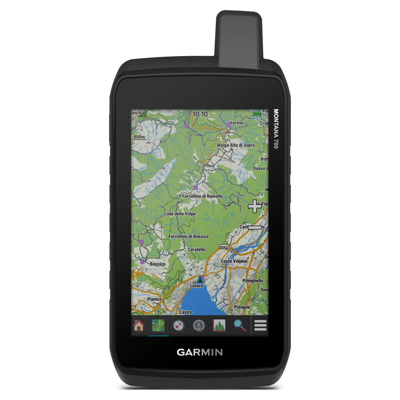
With routable mapping for roads and trails, the Montana 700 handheld brings advanced outdoor features into a sturdy 5” format that’s ideal for navigation on foot, bike, kayak, ATV and more.
Productinformation
With routable mapping for roads and trails, the Montana 700 handheld brings advanced outdoor features into a sturdy 5” format that’s ideal for navigation on foot, bike, kayak, ATV and more.
Two-Way Messaging
Exchange text messages with loved ones, post to social media, or communicate via inReach device to inReach device in the field (active satellite subscription required).
Interactive Sos
In case of emergency, trigger an interactive SOS message to GEOS, a professional 24/7 global monitoring and response center (active satellite subscription required).
Global Connectivity
Instead of relying on cellphone coverage, now your messages, SOS and tracking are transferred via the 100% global Iridium® satellite network (active satellite subscription required).
Inreach Weather
Available inReach weather forecast service provides detailed updates directly to your Montana handheld or paired devices, so you’ll know what to expect en route.
Rugged By Design
This durable, water-resistant handheld is tested to U.S. military standards and features a glove-friendly 5” touchscreen that’s 50% larger than previous Montana models.
City Navigator Maps
Seamlessly transition from trails to road navigation with preloaded City Navigator street mapping, which guides your drive with easy-to-follow turn-by-turn directions.
Topoactive Maps
To navigate your adventures, use preloaded topographical maps for the U.S. and Canada. View terrain contours, elevations, coastlines, rivers, landmarks and more.
Public Land Boundaries
Optional display of federal public land boundaries on topographical maps helps you know that you’re venturing where you’re supposed to be.
Satellite Views
Use direct-to-device downloads of BirdsEye Satellite Imagery (no annual subscription required) to see photo-realistic views and create waypoints based on landmarks.
Abc Sensors
Navigate your next trail with ABC sensors, including an altimeter for elevation data, barometer to monitor weather and 3-axis electronic compass.
Active Weather
Use cellular connectivity2 to access up-to-date Active Weather forecasts through the Garmin Connect™ app.
Dog Tracking
For hunters and trainers, this Montana syncs with compatible Astro® or Alpha® series handhelds (sold separately) to help track sporting dogs in the field.
General
- Physical Dimensions 3.6" x 7.2" x 1.3" (9.19 x 18.30 x 3.27 cm)
- Touchscreen
- Display Size 2.55"W x 4.25"H (6.48 x 10.80 cm); 5" diag (12.70 cm)
- Display Resolution 480 x 800 pixels
- Display Type WVGA transflective, dual orientation
- Weight 14.5 oz (410 g) with included lithium-ion battery pack
- Battery Type rechargeable lithium-ion (included) or 3 AA batteries (not included); lithium recommended
- Battery Life
- GPS Mode: up to 18 hours
- Expedition Mode: up to 330 hours
- Water Rating IPX7
- Mil-Std-810 yes (thermal, shock, water, vibe)
- High-Sensitivity Receiver
- Interface high speed micro USB and NMEA 0183 compatible
- Memory/History 16 GB (user space varies based on included mapping)
Maps & Memory
- Preloaded Maps yes (TopoActive, by Region; Federal Public Lands Map, U.S. only)
- Ability To Add Maps
- Basemap
- Automatic Routing (Turn By Turn Routing On Roads) Yes (with optional mapping for detailed roads)
- Map Segments 15000
- Birdseye yes (direct to device)
- Includes Detailed Hydrographic Features (Coastlines, Lake/River Shorelines, Wetlands And Perennial And Seasonal Streams)
- Includes Searchable Points Of Interests (Parks, Campgrounds, Scenic Lookouts And Picnic Sites)
- Displays National, State And Local Parks, Forests, And Wilderness Areas
- External Memory Storage yes (32 GB max microSD™ card)
- Waypoints/Favorites/Locations 10000
- Tracks 250
- Track Log 20000 points, 250 saved gpx tracks, 300 saved fit activities
- Routes 250, 250 points per route; 50 points auto routing
- Rinex Logging
Sensors
- Gps
- Galileo
- Barometric Altimeter
- Compass Yes (tilt-compensated 3-axis)
- Gps Compass (While Moving)
Daily Smart Features
- Connect Iq™ (Downloadable Watch Faces, Data Fields, Widgets And Apps)
- Weather
- Virb® Remote
- Pairs With Garmin Connect™ Mobile
- Active Weather
- Smart Notifications On Handheld
Safety And Tracking Features
- Livetrack
Outdoor Recreation
- Point-To-Point Navigation
- Compatible With Basecamp™
- Area Calculation
- Hunt/Fish Calendar
- Sun And Moon Information
- Xero™ Locations
- Geocaching-Friendly yes (Geocache Live)
- Custom Maps Compatible yes (500 custom map tiles)
- Picture Viewer
- Led Beacon Flashlight
Inreach® Features
- Interactive Sos
- Send And Receive Text Messages To Sms And Email
- Send And Receive Text Messages To Other Inreach Device
- Exchange Locations With Other Inreach Device
- Mapshare Compatible With Tracking
- Virtual Keyboard For Custom Messaging
Outdoor Applications
- Compatible With Garmin Explore™ App
- Garmin Explore Website Compatible
- Dog Tracking yes (when paired to compatible dog track system)
Connections
Wireless Connectivity yes (Wi-Fi®, BLUETOOTH®, ANT+®)
What's in the box?
Wireless Connectivity yes (Wi-Fi®, BLUETOOTH®, ANT+®)
What's in the box?
- Montana 700
- Lithium-ion battery pack
- USB cable
- Documentation
Specifications
Questions & Answers
Related Reports & Guides
There are currently no blogs connected to this article.
Product Safety Information (GPSR)
Importer
Registered contact information for the responsible company within the EU.
| Name | Garmin Nordic Sweden AB |
|---|---|
| Corporate number | 556698-0354 |
| Address |
Uggledalsvägen 13 427 40 / Billdal |
| Country | Sverige |
| [email protected] |
Included in the collection:
See the full collection
With routable mapping for roads and trails, the Montana 700 handheld brings advanced outdoor features into a sturdy 5” format that’s ideal for navigation on foot, bike, kayak, ATV and more.
Productinformation
With routable mapping for roads and trails, the Montana 700 handheld brings advanced outdoor features into a sturdy 5” format that’s ideal for navigation on foot, bike, kayak, ATV and more.
Two-Way Messaging
Exchange text messages with loved ones, post to social media, or communicate via inReach device to inReach device in the field (active satellite subscription required).
Interactive Sos
In case of emergency, trigger an interactive SOS message to GEOS, a professional 24/7 global monitoring and response center (active satellite subscription required).
Global Connectivity
Instead of relying on cellphone coverage, now your messages, SOS and tracking are transferred via the 100% global Iridium® satellite network (active satellite subscription required).
Inreach Weather
Available inReach weather forecast service provides detailed updates directly to your Montana handheld or paired devices, so you’ll know what to expect en route.
Rugged By Design
This durable, water-resistant handheld is tested to U.S. military standards and features a glove-friendly 5” touchscreen that’s 50% larger than previous Montana models.
City Navigator Maps
Seamlessly transition from trails to road navigation with preloaded City Navigator street mapping, which guides your drive with easy-to-follow turn-by-turn directions.
Topoactive Maps
To navigate your adventures, use preloaded topographical maps for the U.S. and Canada. View terrain contours, elevations, coastlines, rivers, landmarks and more.
Public Land Boundaries
Optional display of federal public land boundaries on topographical maps helps you know that you’re venturing where you’re supposed to be.
Satellite Views
Use direct-to-device downloads of BirdsEye Satellite Imagery (no annual subscription required) to see photo-realistic views and create waypoints based on landmarks.
Abc Sensors
Navigate your next trail with ABC sensors, including an altimeter for elevation data, barometer to monitor weather and 3-axis electronic compass.
Active Weather
Use cellular connectivity2 to access up-to-date Active Weather forecasts through the Garmin Connect™ app.
Dog Tracking
For hunters and trainers, this Montana syncs with compatible Astro® or Alpha® series handhelds (sold separately) to help track sporting dogs in the field.
General
Two-Way Messaging
Exchange text messages with loved ones, post to social media, or communicate via inReach device to inReach device in the field (active satellite subscription required).
Interactive Sos
In case of emergency, trigger an interactive SOS message to GEOS, a professional 24/7 global monitoring and response center (active satellite subscription required).
Global Connectivity
Instead of relying on cellphone coverage, now your messages, SOS and tracking are transferred via the 100% global Iridium® satellite network (active satellite subscription required).
Inreach Weather
Available inReach weather forecast service provides detailed updates directly to your Montana handheld or paired devices, so you’ll know what to expect en route.
Rugged By Design
This durable, water-resistant handheld is tested to U.S. military standards and features a glove-friendly 5” touchscreen that’s 50% larger than previous Montana models.
City Navigator Maps
Seamlessly transition from trails to road navigation with preloaded City Navigator street mapping, which guides your drive with easy-to-follow turn-by-turn directions.
Topoactive Maps
To navigate your adventures, use preloaded topographical maps for the U.S. and Canada. View terrain contours, elevations, coastlines, rivers, landmarks and more.
Public Land Boundaries
Optional display of federal public land boundaries on topographical maps helps you know that you’re venturing where you’re supposed to be.
Satellite Views
Use direct-to-device downloads of BirdsEye Satellite Imagery (no annual subscription required) to see photo-realistic views and create waypoints based on landmarks.
Abc Sensors
Navigate your next trail with ABC sensors, including an altimeter for elevation data, barometer to monitor weather and 3-axis electronic compass.
Active Weather
Use cellular connectivity2 to access up-to-date Active Weather forecasts through the Garmin Connect™ app.
Dog Tracking
For hunters and trainers, this Montana syncs with compatible Astro® or Alpha® series handhelds (sold separately) to help track sporting dogs in the field.
General
- Physical Dimensions 3.6" x 7.2" x 1.3" (9.19 x 18.30 x 3.27 cm)
- Touchscreen
- Display Size 2.55"W x 4.25"H (6.48 x 10.80 cm); 5" diag (12.70 cm)
- Display Resolution 480 x 800 pixels
- Display Type WVGA transflective, dual orientation
- Weight 14.5 oz (410 g) with included lithium-ion battery pack
- Battery Type rechargeable lithium-ion (included) or 3 AA batteries (not included); lithium recommended
- Battery Life
- GPS Mode: up to 18 hours
- Expedition Mode: up to 330 hours
- Water Rating IPX7
- Mil-Std-810 yes (thermal, shock, water, vibe)
- High-Sensitivity Receiver
- Interface high speed micro USB and NMEA 0183 compatible
- Memory/History 16 GB (user space varies based on included mapping)
Maps & Memory
- Preloaded Maps yes (TopoActive, by Region; Federal Public Lands Map, U.S. only)
- Ability To Add Maps
- Basemap
- Automatic Routing (Turn By Turn Routing On Roads) Yes (with optional mapping for detailed roads)
- Map Segments 15000
- Birdseye yes (direct to device)
- Includes Detailed Hydrographic Features (Coastlines, Lake/River Shorelines, Wetlands And Perennial And Seasonal Streams)
- Includes Searchable Points Of Interests (Parks, Campgrounds, Scenic Lookouts And Picnic Sites)
- Displays National, State And Local Parks, Forests, And Wilderness Areas
- External Memory Storage yes (32 GB max microSD™ card)
- Waypoints/Favorites/Locations 10000
- Tracks 250
- Track Log 20000 points, 250 saved gpx tracks, 300 saved fit activities
- Routes 250, 250 points per route; 50 points auto routing
- Rinex Logging
Sensors
- Gps
- Galileo
- Barometric Altimeter
- Compass Yes (tilt-compensated 3-axis)
- Gps Compass (While Moving)
Daily Smart Features
- Connect Iq™ (Downloadable Watch Faces, Data Fields, Widgets And Apps)
- Weather
- Virb® Remote
- Pairs With Garmin Connect™ Mobile
- Active Weather
- Smart Notifications On Handheld
Safety And Tracking Features
- Livetrack
Outdoor Recreation
- Point-To-Point Navigation
- Compatible With Basecamp™
- Area Calculation
- Hunt/Fish Calendar
- Sun And Moon Information
- Xero™ Locations
- Geocaching-Friendly yes (Geocache Live)
- Custom Maps Compatible yes (500 custom map tiles)
- Picture Viewer
- Led Beacon Flashlight
Inreach® Features
- Interactive Sos
- Send And Receive Text Messages To Sms And Email
- Send And Receive Text Messages To Other Inreach Device
- Exchange Locations With Other Inreach Device
- Mapshare Compatible With Tracking
- Virtual Keyboard For Custom Messaging
Outdoor Applications
- Compatible With Garmin Explore™ App
- Garmin Explore Website Compatible
- Dog Tracking yes (when paired to compatible dog track system)
Connections
Wireless Connectivity yes (Wi-Fi®, BLUETOOTH®, ANT+®)
What's in the box?
Wireless Connectivity yes (Wi-Fi®, BLUETOOTH®, ANT+®)
What's in the box?
- Montana 700
- Lithium-ion battery pack
- USB cable
- Documentation
There are currently no blogs connected to this article.
Importer
Registered contact information for the responsible company within the EU.
| Name | Garmin Nordic Sweden AB |
|---|---|
| Corporate number | 556698-0354 |
| Address |
Uggledalsvägen 13 427 40 / Billdal |
| Country | Sverige |
| [email protected] |